Photographs
Home
Gallery
Pricing
Copyright Notice
Information for Photographers
Equipment Reviews
Field How-to
Picturesque Locations
Oneonta Trail to Bell Creek 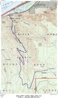
What a fantastic hike. Portions of this hike rank right up there with the best old growth in the area. One of my favorite things is old growth cedars "dripping" with stunning green moss, and the Oneonta trail has plenty of this. The trail starts along the Columbia river scenic highway, just after the marking for Oneonta Gorge. In the beginning this trail passes through some less interesting old growth (though still spectacular; just not like what's to come).
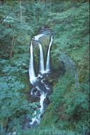
In this picture of Triple Falls, you can see the foot bridge
which the Oneonta Trail goes over just a few hundred feet from
where the picture was taken. Once you cross this creek the trail
gets really interesting.
I really should have taken more pictures in this area, but we were running behind schedule and had to rush through. I hadn't ever been up to Bell Creek before, so I wanted to see what it was like... in foresight, I wish I had enjoyed my stay in the richer forest along Oneonta Creek...
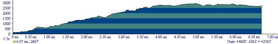
On the map you can see that right after you cross Oneonta Creek for the second time, you can take a trail off to the left which will also get you to Bell Creek. I don't recommend doing this, because in spots the trail is completely overgrown with vegetation and passing can be difficult, especially in the spring and summer. Even if it was easily passable though, the forest on the east side of the gorge isn't nearly as interesting as the west side. The east side is mostly all second growth, with just a few patches of old growth. For a more interesting hike, stay on the highlighted trail. The map is actually out of date, as the trail no longer is quite as steep as the map shows. This trail use to be one of the steepest in the gorge (as the map shows), but it has recently (well, at least since the map was produced, probably some time in the 70s) been regraded and isn't nearly as steep as this shows. You can see by the elevation profile at the top of the page that the hike is 6.87 miles one way, but that actually isn't correct. I traced the old trail on the map, so this figure is slightly under what the actual distance is. The regraded trail probably adds around one mile in each direction to the overall length of this hike.
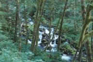
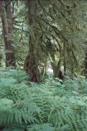
Once you hit the top of the ridge (about 4 miles in and 3000 feet up) the forest becomes quite peculiar. It's all old growth, but there is virtually NO undergrowth to speak of. A burn may have been through there at some point and the undergrowth just has never grown back. Unfortunately I didn't take a picture of it, but I should have just to record the scene. A number of years ago the Bell Creek trail was completely washed away due to the very saturated ground it's on, but a few years ago they completely redid the trail, building it about 6 inches above the ground. They truly did a fantastic job, but for some reason they aren't maintaining it! They spent lots of money to build this trail up and now they aren't maintaining it... it's really a shame. Due to this, at times the vegetation growing over the trail is pretty bad. A few times we thought we were going to have to turn around, but kept on plowing through. There wasn't only vegetation on the trail, but quite a few blow downs. As you can see on the map, we didn't quite get to Bell Creek. We were forced to stop about a fifth of a mile away from it. The vegetation growing over the trail completely blocked it and we couldn't go any further. At the end of the trail there are some 8 foot in diameter Cedars. It's a shame we didn't get to see those. Due to the saturated soil along the Bell Creek trail, this is a great place to see large red cedars. There were quite a few of them along the trail. There was also lots of skunk cabbage. This stuff looks really cool; almost like it's from another planet. Once we got back onto the east side of Oneonta Creek (into that rich forest I love so much) the sun had almost sunk behind the ridge. I always enjoy hiking through forests like this much more when the sun isn't directly on the vegetation. I wanted to wait until the sun had left so that the lighting would be softer and I could enjoy the forest better. My hiking partner didn't, so he went ahead as I waited. Once the sun was behind the ridge I started moving again and the forest looked so amazing. I couldn't capture the sheer grandeur of it on film; it was truly stunning. The whole way back I had a huge grin on my face, thinking the whole time, "Does a place like this really exist?" The forest is just so beautiful. Even though above I explained the hike as I was going up, all of the pictures were taken walking back. I had many of the same pictures on the way up, but they aren't nearly as good. Many of them have areas where the sun burns out portions of the picture. After I took the second picture on this page I picked up my tripod and started walking along the trail again, amazed at its beauty. Right when I rounded a corner I saw a large brown bump about 10 feet in front of me which frightened me for a moment, until I realized what it was: A Doe with two baby deer crossing the trail. Apparently I frightened them more than they did me. The female deer turned her head and when she saw me all three of them took off running down the trail. At one point they stopped and looked back. We sat there looking at each other for a while. I figured I may be able to get a picture of them, but as I started pulling out my camera they shot up the side of a ridge. By the time I got up to where they ran up they were long gone. My senses were already so elevated by the forest and seeing those deer made me truly feel like I was in the wild. I felt connected to it. It was really an awesome feeling. For portions, this hike is... errr... did I forget to tell you about the mosquitos? Well... the mosquitos were out... and they were out in force! For some stupid reason we had totally forgoten that they could be out, and didn't double check our bug repellent supply. It turns out we had about 1/8th of a stick of Cutter's left. That lasted about 10 minutes. These little bastards were all over us for the WHOLE hike. Every single time I stopped to take a picture they harassed me about 10 times more furiously than when I was hiking. The mosquitos really took a lot of the enjoyment out of this hike... They also made me not want to stop and take pictures, so I think I missed a lot of shots I wouldn't have if it weren't for them. I knew I was being bitten by them, but I didn't know how badly. No welts showed up until the next morning... I'm not sure how many total bites I got, but it was quite a few. "Well what's quite a few?" you're thinking. Maybe 10? 15? 30? On my face, neck, and behind my ears I counted 35. On the top of my head there were probably 7-10. On each leg there were 40-50 bites. Oh, and these weren't just bites. Each one was a huge WELT. Continuing, I couldn't really count the ones on my shoulder, but just by feel I counted ~30-40 on EACH shoulder. Total, I probably had about 200 bites around my body. And they were horrible... itching like crazy. I even had one on the palm of my right hand! That one didn't just itch, it HURT. I was suffering for about 2 days before they finally went away. So if you're going to go on this hike (which you definitely should), bring bug repellent! And lots of it too... The bugs should only be out for about 3 weeks out of the year, but it's hard to tell when those three weeks are. If you go in early May you SHOULD be all right. Same with late summer. But you never know... you should be prepared. This truly is a fantastic hike though. I'm not sure if going all the way up to Bell Creek is worth it (for my tastes), but the whole thing is interesting. What I think a better hike would be (if you're in good shape), is to start at Oneonta Trail, and climb Larch Mountain. On the way back you can also make a loop and follow the Horsetail Falls trail down to Pony Tail Falls, and Horsetail falls. This would add about a mile. I really wanted to do this, but by the time I got to the trail cut off it was about 8:20 and there wasn't really enough light left in the day. Oneonta Creek is a very beautiful area though. Some of the best old growth in the area. I highly recommend the hike. |
|
|