Photographs
Home
Gallery
Pricing
Copyright Notice
Information for Photographers
Equipment Reviews
Field How-to
Picturesque Locations
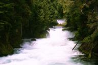
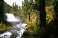
Sahalie and Koosah Falls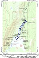
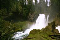 What an awesome couple of falls. These two falls have the full
force of the McKenzie river pouring over them. Now granted, the
river isn't as massive here as it is in the Eugene area, it is
still a fairly large river... going over two 100 foot waterfalls.
Incredible.
What an awesome couple of falls. These two falls have the full
force of the McKenzie river pouring over them. Now granted, the
river isn't as massive here as it is in the Eugene area, it is
still a fairly large river... going over two 100 foot waterfalls.
Incredible.
1999 had a very long winter in this area. As a result, many trails opened very late in the year. I called the McKenzie River Ranger's station before going out to these falls and was told, "There may be some snow on the trail near the top, but it shouldn't be too bad." You couldn't even drive to the Koosah Falls trail head because it was under a foot of snow, and this was mid May! "Some" snow huh... there was no snow around the falls themselves, but that's because they are in exposed areas. There was at least 3 feet of snow over most of the trail, and up to 5 feet in some areas. This made for very slow going. We went on a Thursday afternoon and were the only people on the trail. We started at Sahalie Falls, where there's a large parking area and a short paved trail down to a viewpoint of the falls. You can also walk a short paved trail up to the top of the falls and overlook it. Once we did that, we turned around and came back south on the trail, towards Koosah Falls.
The forest in this area is fairly typical of mid elevation old growth. It was very nice in parts, but certainly not the main attraction on this hike.
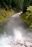
Continuing on down the trail there is another paved path down to a bench where you can view the falls. The view from this spot actually isn't that great, and I don't think I took any pictures of the falls from there. I did take some from that point towards the other direction though, down river. For me that was the view at this spot; there are better views of Koosah falls...
After you pass Koosah Falls the trail doesn't follow the McKenzie as closely any more, and you can appreciate the forest a bit. Once you hit the paved road at Carmen Reservoir, it's time to turn right and walk down the paved road a bit until you get to the trail head on the west side of the river. The trail is not RIGHT after you cross over the river though. There does appear to be a trail here, but I'm not sure where it leads, except to a dead end. The real trail is a little bit farther down the road, and there is actually a sign for it.
The snow on the west side of the trail was much worse than on the east. On the east side we certainly were hiking on snow, but it wasn't much of a problem. On the east side it was pretty bad. We would be hiking along on snow, and then all of a sudden fall in up to our knees or waists. Due to this we were moving extremely slow. A few minutes after we started on this side of the trail it started to rain... then hail... then snow... in the middle of May! The snow was so bad that we would loose the trail for 5-10 minutes at a time before finally finding it again. When we were just south of Sahalie Falls we had lost the trail for about 20 minutes, it was raining, cold, and miserable, plus my hiking partner had to be back in town by 7:30 for a meeting... so we decided we had better turn back. That was a bummer, because from the east side of Sahalie Falls it looked like I could have gotten some spectacular pictures from the west side trail. Oh well. I'll certainly be heading back here again next year. This is a very short hike; doing the whole loop (as shown on the map) is only 2.9 miles, so anyone can do it. Just because it is so short doesn't mean it isn't rewarding though. This hike has lots of fantastic views packed into a small package. Especially since it is so easy, you should definitely check it out. A waterfall lover will really enjoy it. |
|
|